


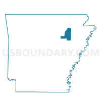
Tuckerman Outside Voting District, Jackson County, Arkansas
About
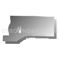
Outline

Summary
| Unique Area Identifier | 526793 |
| Name | Tuckerman Outside Voting District |
| County | Jackson County |
| State | Arkansas |
| Area (square miles) | 62.96 |
| Land Area (square miles) | 62.66 |
| Water Area (square miles) | 0.29 |
| % of Land Area | 99.54 |
| % of Water Area | 0.46 |
| Latitude of the Internal Point | 35.73512430 |
| Longtitude of the Internal Point | -91.15627820 |
Maps


Graphs
Select a template below for downloading or customizing gragh for Tuckerman Outside Voting District, Jackson County, Arkansas


Neighbors
Neighoring Voting District (by Name) Neighboring Voting District on the Map
- Campbell Station Voting District, Jackson County, AR
- Dobson Pitts Voting District, Poinsett County, AR
- Greenhaw Voting District, Jackson County, AR
- Grubbs Voting District, Jackson County, AR
- Hickory Grove Voting District, Jackson County, AR
- Little Texas Voting District, Craighead County, AR
- Swifton Voting District, Jackson County, AR
- Tuckerman Ward 1, Jackson County, AR
- Tuckerman Ward 2, Jackson County, AR
- Tuckerman Ward 3, Jackson County, AR
- Waters Store Voting District, Jackson County, AR
Top 10 Neighboring County Subdivision (by Population) Neighboring County Subdivision on the Map
- Village township, Jackson County, AR (2,158)
- Bird township, Jackson County, AR (2,102)
- Glass township, Jackson County, AR (1,088)
- Jefferson township, Jackson County, AR (1,064)
- Grubbs township, Jackson County, AR (572)
- Little Texas township, Craighead County, AR (198)
- Dobson township, Poinsett County, AR (170)
Top 10 Neighboring Place (by Population) Neighboring Place on the Map
Top 10 Neighboring Unified School District (by Population) Neighboring Unified School District on the Map
Top 10 Neighboring State Legislative District Lower Chamber (by Population) Neighboring State Legislative District Lower Chamber on the Map
- State House District 74, AR (30,962)
- State House District 58, AR (27,318)
- State House District 56, AR (24,583)
Top 10 Neighboring State Legislative District Upper Chamber (by Population) Neighboring State Legislative District Upper Chamber on the Map
- State Senate District 14, AR (91,166)
- State Senate District 12, AR (83,956)
- State Senate District 15, AR (71,063)
Top 10 Neighboring 111th Congressional District (by Population) Neighboring 111th Congressional District on the Map
Top 10 Neighboring Census Tract (by Population) Neighboring Census Tract on the Map
- Census Tract 12, Craighead County, AR (4,835)
- Census Tract 4804, Jackson County, AR (4,669)
- Census Tract 4801, Jackson County, AR (3,490)
- Census Tract 4906, Poinsett County, AR (1,698)